In recent years, the availability and affordability of Global Navigation Satellite Systems (GNSS) receivers has made it possible for grassroots-level racers to adopt cost-effective data logging and analysis solutions.
Given the many choices in the market, and the many factors that can affect the quality and usefulness of GNSS information, there are a number of points to consider for those looking to step into this technology.
Satellite Constellations
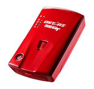
The first GNSS satellite constellation deployed was the Global Positioning System, or GPS (United States). Since it’s launch, additional satellite constellations have become available such as Galileo (European Union) and GLONASS (Russia). While there are popular receivers such as the Qstarz BT-Q818XT which only make use of the GPS constellation, the highest performing receivers on the market today make use of multiple constellations.
Update Rates
GNSS receivers offer a range of available update rates. The minimum usable rate for motorsports applications is 5 updates per second (5Hz), however an update rate of 10Hz and above is optimal.
Antenna Design
The ideal receiver uses a dedicated, remotely-mounted GNSS antenna, such as with the Race Capture devices. These seem to result in the best signal quality.

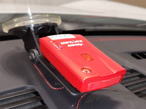
The puck-style units, such as the Qstarz, are not as optimized but they do present a cost-effective solution.
The actual antenna is hidden from view by a plastic cover. When mounting, make sure that the receiver is level with the ground, and the top of the unit faces upwards.
GNSS antennas commonly built into Wi-Fi cameras are not accurate enough to compare one lap of a circuit to another. The maps may look smooth when presented on a video overlay, but as far as driver development is concerned they offer insufficient accuracy.
Accuracy of GNSS Speed
GNSS speed is calculated using frequency Doppler effect, and is therefore quite accurate. The speed value does lag by a small amount, however the amount of lag differs among receivers. SoloStorm and CircuitStorm will compensate for this.
Signal Quality
GNSS is a suitable source of position and speed information for motorsports logging and analysis applications. When used under optimal conditions, the position information is sufficient to compare driving lines between short courses (sub-60 seconds), as well as longer courses when correcting for drift in post-processing.
When conditions become less than optimal, course maps can diverge, and speed readings can become jittery and delayed.
Optimal Conditions for GNSS Receivers
There are a number of factors that contribute to the quality of the GNSS data that is processed by your receiver. These fall into two categories: factors that you can control, and factors that you can’t.
Mounting
Mount your GNSS receiver (or antenna, if it is separate) upright, and in a place that has a clear, unobstructed view of the sky. On cars with a roof, this is dead-centre on the roof itself, which helps to provide an improved Ground Plane for the antenna. On cars with an open cockpit, the top of the main or secondary roll hoop is acceptable.
Satellite Lock
Once you turn on your GNSS receiver, you need to give it time to develop a satellite lock. The more satellites it can find and lock on to, the more accurate the position and speed information will be.
Under cold-start conditions, a basic lock can be found in about 5 minutes, however this is not sufficient for motorsports needs. Your GPS receiver can take up to 15 minutes do download all of the updated Almanac information from the satellites that it has found, and another 20 minutes to search for additional satellites.
Therefore, while you can simply turn on a GNSS receiver and use it after a couple of minutes, the data will not be of sufficient quality for motorsports applications.
It is, however, fairly simple to obtain a good GNSS lock when you arrive onsite in the morning. Mount and turn on your receiver, leave it stationary for 30min or more, and leave it on for the rest of the day.
Setting Markers
If you choose to set course markers, the important information to capture is the relative position of the markers to one-another. To do this, set them all as quickly as possible – do NOT set the staging and start, walk the entire course for 15 minutes, and then set the finish. This will lead to the finish position being relatively incorrect due to the error that can occur over longer periods of time.
Factors Not under your control
A number of factors can cause a drop in GNSS signal quality, such as not having a clear view of the sky (this is more of an issue in hill climbs), the presence of large metallic structures (think bleachers or buildings), as well as atmospheric conditions (weather), and jamming (Russia).
GNSS Quality Indicators
The key indicators of GNSS signal quality are Satellite Count and Dilution of Position (SoloStorm and CircuitStorm refers to DOP simply as ‘Accuracy‘). While both of these values are not supported by all of the GNSS sources that SoloStorm and CircuitStorm may use, they are available via most of them.
A warning will appear on the Logging Screen to highlight the GNSS quality information if SoloStorm or CircuitStorm thinks that it is too low. Under these conditions, you will still be able to log data, however the quality may not be optimal for comparing logs.
Satellite Count
As a general rule, higher satellite counts equate with improved signal quality. For the 10Hz Qstarz receivers, as well as the Race Capture receivers, 9 satellites and above is acceptable, with 11 or 12 yielding excellent results.
It is important to note that satellites count can drop and rebound during a run. This can be seen in a log when enabling the Satellite Count trace. Frequent dropping of satellites will lead to poor signal quality, and can be an indicator that something is wrong – either the unit is incorrectly mounted, or a sufficient satellite lock has not been achieved.
Recovering from a low-quality GNSS signal
If you are experiencing low-quality GNSS data, you can try to perform a cold restart on your GNSS receiver. For the Qstarz and Race Capture units, this means terminating power to the unit (remove the battery from the Qstarz) for 5 minutes, powering it back on, then allowing sufficient time as described above for a satellite fix to occur.
Under competition conditions, this may not be practical, and thererfore SoloStorm has the ability to correct for SMALL amounts of GNSS drift between logs, by comparing position, distance, and heading at key points in the log. This option can be enabled in the Analysis Settings.